 |
| Mount St Helens |

The sun rose over Lewiston, Idaho clear and bright. It's unfortunate the sunlight couldn't reach the beautiful town of Lewiston through the smog coming from the paper mill and fertilizer factory. The smell wafting over the town permeating everything was over powering. It smelled like a combination of a dirty diaper and death. A very fitting scenario given we were close to Hells Gate State Park. The smog was so thick the sunlight was almost totally obliterated in the beautiful downtown area where modern sculptures dotted the sidewalks and murals covered businesses brick walls. It was such an odd combination of extremes. How is that someone would choose to live in this hellacious smelling town and then adorn it with beautiful art?

 |
| Sculptures in downtown Lewsiton, Idaho |
Given the fact we were so close to Hell (s Gate State park that is) it was still amazing how much smog covered the town. We headed left out of the hotel and saw a sign stating we were on Route 12 east instead of west.
We did a U turn and headed back through downtown only to see another sign for Route 12 east heading in this direction. We tried to turn around and ended up driving over a bridge into Washington. In the attempt to turn around on the Washington side of town we kept finding one way streets and turning lanes preventing us from heading back into downtown. It reminded of the line from the Eagles song Hotel California "you can check out anytime you want but you can never leave." We wanted so much to leave this hell like area. We had skipped breakfast and checked out early in order to put as much distance from this town as we could yet we couldn't find the way out of town. Finally after finding Route 12 west we headed out of town. The smell from the town filled the car and even with the windows rolled down in the cold morning air it took a half hour and thirty miles before the car began to smell better.
 |
| On top of the plain. Incredibly flat for miles in every direction. |

The road out of Lewiston ran long the Clearwater River for miles then turned left and headed up a valley (or gulch as they call them here). It climbed through a wide valley that gradually became narrower and steeper until it emerged on a large flat open plain. The scenery here was all brown. Fields of grain that had been chopped or plowed fill the landscape and grain elevators dotted the horizon as you approach the few towns. Some of the elevators show signs of where a town used to be and has been abandoned except for the necessity of the farmers grain elevator. After topping the hill at 2800 feet and seeing the wide open plain the road dropped back down into another valley and wound through the varying shades of brown landscape. The ground looked like a piece of cloth that had been folded and rumpled to produce rolling hills. Almost every square foot was being used for farming. All along the road we passed barns and houses long since abandoned and left to rot then collapse.

I had always thought of Washington State as being lush green mountains and high peeks. I was stunned by the stark, dry, brown landscape in this portion of the state. It seemed almost like a desert despite the pervasive farming. In many places long wheeled irrigation equipment were present in the fields so perhaps this is the case. Throughout the valleys up on the hilltops we began to see wind farms. The huge alien looking white turbines were atop many hills as we drove west. The turbines often seemed to stretch for miles atop the brown hills.

Soon towns began to appear more frequently and every town had a huge grain elevator and railroad tracks stretching for miles. Long trains pulling open cars for carrying the grain rolled along the tracks by the road. The locomotives were brightly colored. A nice change from the black and white Norfolk Southern locomotives back home.


The first town we came to hours after leaving Lewiston was Pomeroy, Washington. A quaint little farming town in the brown rolling hills. After a quick stop for gas and a late breakfast at Tanya's Cafe we poked around town a little. There were a ton of signs from the 1950's era in the town and it was fun looking at them. While eating at Tanya's we met a 72 year old man riding a recumbent bicycle. He had on a bright yellow outfit and helmet. His bike sported a windshield and 200 lumen LED flashlight on the front. He had bought the bike a year ago and had already logged 3000 miles on it. Earlier in the summer, he had made the ride we had just done by car from Missoula, Montana over Lolo pass through Idaho into Pomeroy, Washington. It took him three days. The drive in the car was long enough for me as that was the most grueling part of this trip to date. This man had rode to the cafe to have breakfast with some fellow seniors and there topic of discussion ranged from the outcome of the last Junior High School football game to AARP (or as they called it the American Association of Raisins and Prunes) benefits.
 |
| Pomeroy, Washington |
The next stop down the road was Walla Walla, Washington. I've always heard about Walla Walla mostly because of the funny name, so we had to stop while in the neighborhood. It's a beautiful city with tree lines streets and a bustling downtown. This is Washington's wine region. Although I can't figure out how they grown grapes in this brown seemingly dry landscape. The soil here is a gray powder. It doesn't seem like it would be conducive to growing grapes let alone anything else. We had been told we had to do some wine tasting while in the area and the downtown area sported many wine shops that were all still closed at 11:30am. Apparently they were not going to accommodate us Easteners who were still on EST and up for some wine. It was 2:30 in the afternoon back home so we felt it to be a perfectly acceptable time for a cocktail.
 |
| Found in Walla Walla. I'd eat at any place that puts bacon in their business name. |

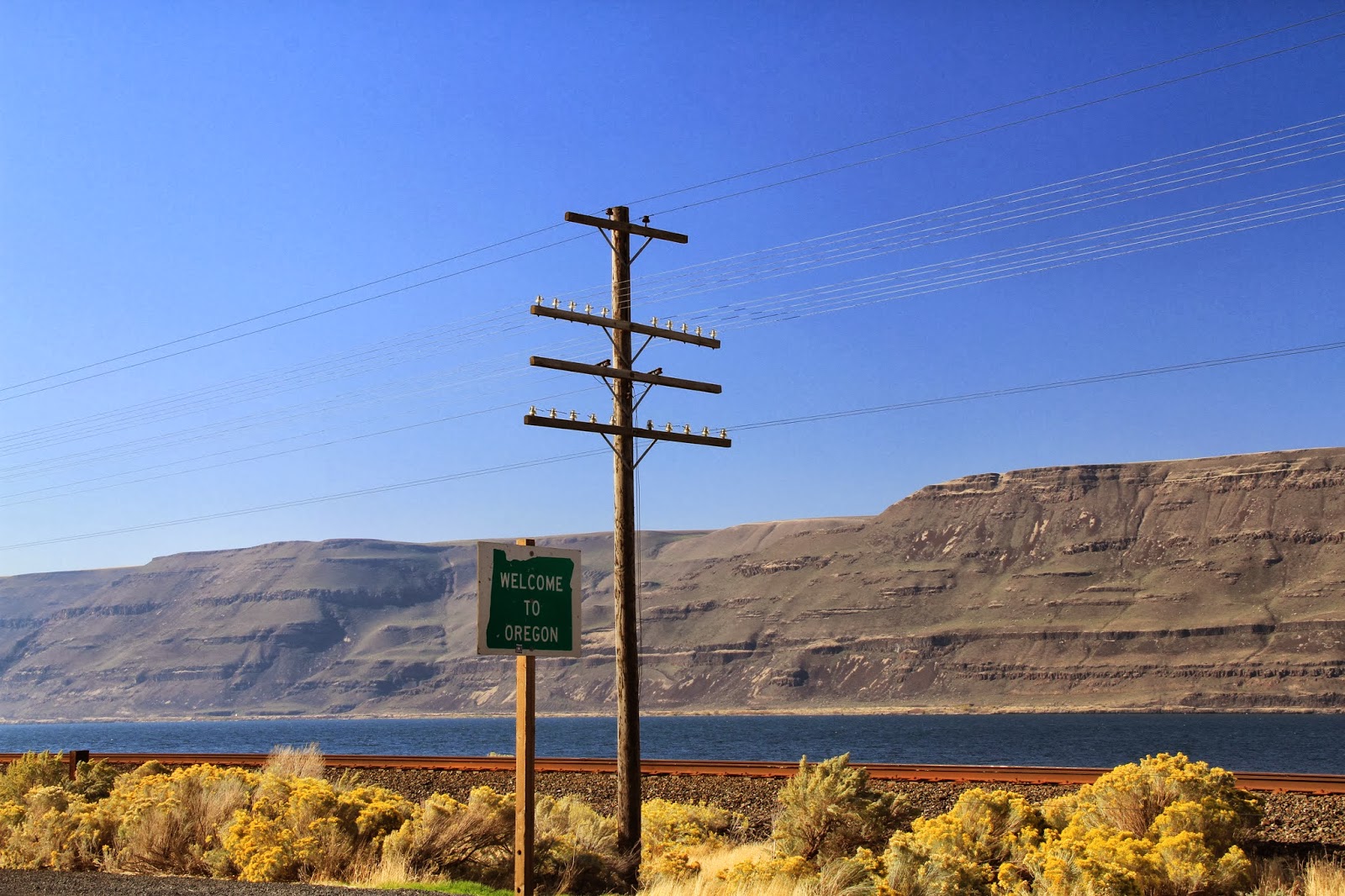
Leaving Walla Walla, we soon crossed the quarter mile wide Columbia River into Oregon and picked up I82 headed west. This led along the south side of the river and we had great views of Washington State across the river. Train tracks ran alongside then under the interstate and through tunnels. On the other side of the river we could see a secondary road and train tracks as well. The landscape still was brown and rolling yet cliffs began to emerge along the river. At one point we went through a portion of the Snake River Canyon and traffic was heavy. This was a drastic change from the empty interstate of South Dakota and Wyoming. It made us long for the wide up plains and rugged landscape of those two states which we agreed were our favorite. We have vowed to return there one day to explore some more.
 |
| Two Sisters Rocks |
 |
| View across the River into Washington |
 |
| Barge on the Columbia River |
 |
| Train draw bridge on the Columbia River |


Traffic picked up as we approached Portland, Oregon and soon it was time to turn off for our tourist event of the day. We crossed the Columbia River on a long draw bridge and turned left along the river. The road ran through some tunnels as it undulated over the hills along the river bank. Soon we found our turn and headed into the mountains towards our destination, Mount St Helens. The road twisted and turned over a steep mountain with a the mountainside on our left and a steep drop off on the right. There was not a guard rail in sight as we climbed over the mountain and through the thick forest. The pine trees and aspens rose a hundred feet on either side of the road and created a tunnel at blocked out all sunlight on the corridor we were travelling on. We passed a large herd of elk grazing along the side of the road and they were oblivious to our passing. Soon the forest became even more dense as we headed into the Mount St Helens region. The forest was a boreal rain forest similar to Alaska and in Russia. Moss hung from the trees and clung to everything including the road side.

The mountain road twisted and turned past a vista where we had good views of the mountain. We stopped to take pictures alongside a group of young guys on duel sport motorcycles who were taking a break from their ride. The volcanic mountain loomed high above the surrounding rounded peaks. The jagged snow covered dome was bare of trees and was a reminder of the sign we had passed warning we were entering a volcanic activity region. An hour after first seeing the mountain we wound our way up to the closest vantage point for viewing it close to the base. We passed the bivouac area for the people who attempt to climb the resting volcano. The landscape looked foreign with rock and powdery ash everywhere. A huge slide (avalanche) had recently covered the road and had been cleared. The ash and rocks were piled high along the road where the forestry service had cleared it. This is a beautiful area. I had always imagined exploring the Pacific northwest woods. This trip only made me want to do it more. We took some pictures and as it was getting dusk (and we didn't want to ask Sasquatch for directions back down the mountain), we headed back toward civilization.

 |
| View from the base at dusk |
Today's leg of the journey ended in Longview, Washington just north of Vancouver. Tomorrow it's on through Cathlamet up the coast toward Seattle. It occurred to me today while driving just how surreal this trip seems. The magnitude of the things I've seen and the fact that I reminded myself that I wasn't making a loop through the country seemed strange. Tomorrow I will be making a literal right turn and start the journey north. It's not a return to my old life. For now it's a one way trip that so far I have not regretted taking.
 |
| Old Dodge truck found along a side street in Pomeroy, Washington |

 The sun rose over Lewiston, Idaho clear and bright. It's unfortunate the sunlight couldn't reach the beautiful town of Lewiston through the smog coming from the paper mill and fertilizer factory. The smell wafting over the town permeating everything was over powering. It smelled like a combination of a dirty diaper and death. A very fitting scenario given we were close to Hells Gate State Park. The smog was so thick the sunlight was almost totally obliterated in the beautiful downtown area where modern sculptures dotted the sidewalks and murals covered businesses brick walls. It was such an odd combination of extremes. How is that someone would choose to live in this hellacious smelling town and then adorn it with beautiful art?


 The road out of Lewiston ran long the Clearwater River for miles then turned left and headed up a valley (or gulch as they call them here). It climbed through a wide valley that gradually became narrower and steeper until it emerged on a large flat open plain. The scenery here was all brown. Fields of grain that had been chopped or plowed fill the landscape and grain elevators dotted the horizon as you approach the few towns. Some of the elevators show signs of where a town used to be and has been abandoned except for the necessity of the farmers grain elevator. After topping the hill at 2800 feet and seeing the wide open plain the road dropped back down into another valley and wound through the varying shades of brown landscape. The ground looked like a piece of cloth that had been folded and rumpled to produce rolling hills. Almost every square foot was being used for farming. All along the road we passed barns and houses long since abandoned and left to rot then collapse.
  I had always thought of Washington State as being lush green mountains and high peeks. I was stunned by the stark, dry, brown landscape in this portion of the state. It seemed almost like a desert despite the pervasive farming. In many places long wheeled irrigation equipment were present in the fields so perhaps this is the case. Throughout the valleys up on the hilltops we began to see wind farms. The huge alien looking white turbines were atop many hills as we drove west. The turbines often seemed to stretch for miles atop the brown hills.
  Soon towns began to appear more frequently and every town had a huge grain elevator and railroad tracks stretching for miles. Long trains pulling open cars for carrying the grain rolled along the tracks by the road. The locomotives were brightly colored. A nice change from the black and white Norfolk Southern locomotives back home.


 Traffic picked up as we approached Portland, Oregon and soon it was time to turn off for our tourist event of the day. We crossed the Columbia River on a long draw bridge and turned left along the river. The road ran through some tunnels as it undulated over the hills along the river bank. Soon we found our turn and headed into the mountains towards our destination, Mount St Helens. The road twisted and turned over a steep mountain with a the mountainside on our left and a steep drop off on the right. There was not a guard rail in sight as we climbed over the mountain and through the thick forest. The pine trees and aspens rose a hundred feet on either side of the road and created a tunnel at blocked out all sunlight on the corridor we were travelling on. We passed a large herd of elk grazing along the side of the road and they were oblivious to our passing. Soon the forest became even more dense as we headed into the Mount St Helens region. The forest was a boreal rain forest similar to Alaska and in Russia. Moss hung from the trees and clung to everything including the road side.
 The mountain road twisted and turned past a vista where we had good views of the mountain. We stopped to take pictures alongside a group of young guys on duel sport motorcycles who were taking a break from their ride. The volcanic mountain loomed high above the surrounding rounded peaks. The jagged snow covered dome was bare of trees and was a reminder of the sign we had passed warning we were entering a volcanic activity region. An hour after first seeing the mountain we wound our way up to the closest vantage point for viewing it close to the base. We passed the bivouac area for the people who attempt to climb the resting volcano. The landscape looked foreign with rock and powdery ash everywhere. A huge slide (avalanche) had recently covered the road and had been cleared. The ash and rocks were piled high along the road where the forestry service had cleared it. This is a beautiful area. I had always imagined exploring the Pacific northwest woods. This trip only made me want to do it more. We took some pictures and as it was getting dusk (and we didn't want to ask Sasquatch for directions back down the mountain), we headed back toward civilization.


No comments:
Post a Comment